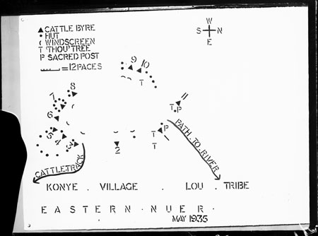
Map of Nuer village
115 x 83 mm | Negative glass plate gelatin
Date of Print:
Unknown
Accession Number:
1998.353.69
Description:
A map of Konye village in eastern Nuerland stenciled by Evans-Pritchard onto a large sheet of paper and pinned to the interior wall of a building, almost certainly in Oxford, and probably in the late 1930s when he was Research Lecturer in African Sociology.
This map adds several details not included on his published version, including the location of 'thou' trees, shrine posts, a path to the river and a cattle path, as well as a rough scale measured in paces.
Photographer:
Unknown. Possibly Edward Evans-Pritchard
Date of Photo:
1937 - 1940 circa
Region:
[Southern Sudan] Jonglei Konye
Group:
Nuer Lou
Notes:
A different version of this map was published by Evans-Pritchard on page 10 of
Kinship and Marriage Among the Nuer
(Oxford, Clarendon Press, 1951) [CM 12/01/2006]
PRM Source:
Edward Evan Evans-Pritchard
Acquired:
Donated 1966
Other Owners:
E. E. Evans-Pritchard Collection
Class:
Graphic Art , Writing , Navigation
Keyword:
Map
Primary Documentation:
One of four glass plates found in a Kodak Bromide paper box among the Evans-Pritchard Collection, labeled in red ink in Evans-Pritchard's hand 'Nuer Kinship Diags' & in another hand in ms pencil 'Dr Evans-Pritchard Exeter College Oxford' [CM 06/01/2006]
Recorder:
Christopher Morton 12/01/2006 [Southern Sudan Project]